Opi lisää yhteisestä maailmanperinnöstämme Struven ketjusta, vieraile mittauspisteillä ja tapaa herra Struve! Avajaiset 1.6. 13.00 Näyttelyn avajaissanat 13.20 ja 15.00 Yleisöluento Struven ketjusta pohjoisessa, AUDITORIO 16.15 Opastettu retki Jyppyrävaaralle Lär dig...


At the Top of the World Heritage
The Northern parts of the World Heritage Struve Geodetic Arc
The Northern parts of the World Heritage Struve Geodetic Arc project aims to improve the accessibility and knowledge of the Struve Geodetic Arc in Finland, Sweden and Norway.
Events
Ditt världsarv – Sinun maailmanperintösi, Övertorneå
Lär dig mer av vårt gemensamma världsarv Struves meridianbåge, besök mätningspunkterna och till och med träffa Herr Struve! Invigning 17/5 kl. 18 Tal om världsarvets betydelse ur olika perspektiv - varför är vi här i dag? Talare mm. Robert Grape Ylva Ylinenpää...
Training course for teachers in Alta
On the 11th of May, Interreg Nord project “The Northern Parts of World Heritage Struve Geodetic Arc" will organize a training course for teachers in Alta. The course is headed by project partners Alta Museum and Nordnorsk Vitensenter. The partners have collaborated to...
Sinun maailmanperintösi / Ditt världsarv
Suomeksi >På svenska (obs! finsk tid!)>Tutustu yhteiseen maailmanperintöömme Struven ketjuun Rajalla -kauppakeskuksen näyttelytilassa Kortteerissa 11.4. - 1.5.2022. Avajaiset 11.4., opastettuja kierroksia 19.4 ja 27.4 klo 13-14.Ohjelmaa kaikenikäisille 11.4....
Sinun maailmanperintösi – Ditt världsarv: Alatornion kirkko
Tervetuloa ke 11.5. klo 18-20 koko perheen voimin tutustumaan yhteiseen maailmanperintöömme Alatornion kirkkoon, sen ympäristöön ja sen osaan maapallon mittanauhana. Aikamatkalle 1800-luvulle sinua johdattelevat Aineen taidemuseo, Tornion seurakunta ja Maailmanperintö...
Recent News
Exhibition for Struve Geodetic Arc at Gjenreisningsmuseet in Hammerfest
Check out opening hours and like the museum FB page on https://www.facebook.com/gjenreisningsmuseet/?ref=page_internal.Struve Geodetic Arc’s northernmost measurement point is located in Hammerfest, northern Norway. Gjennreisningsmuseet is opening the exhibition about...
Update on ultrahaptic experiment
By Juha Orre, Lapland University of Applied Sciences Two teams of Lapland UAS innovation course students developed ideas for ultrahaptics experiment in spring 2021. The project team evaluated the ideas and ended up to further design interactive kiosk with...
Measuring Points 360 Interactive Virtual Experience
by Jari Penttinen, Lapland University of Applied Sciences The goal of 360 photo and interactive experience is to present the measuring points of the Struve Arc in virtual 3D format. The experience utilizes VR goggles. In a VR environment, the end-user can...
Exploring, learning, doing – capacity building status
The Northern parts of the World Heritage Struve Geodetic Arc project team has gathered a huge amount of background information concerning the Struve Geodetic Arc, starting from archives and proceeding but not limited to many site visits and collaboration with experts....
Download brochure “Tornio and the measuring of the Earth”
At the Top of the World HeritageA brochure "Tornio and the measuring of the Earth" tells about triangulation measurements in Tornio area in the 1800s. The brochure can be downloaded as a pdf. This brochure was produced by the ‘Northern parts of the World Heritage...

About the Project
World Heritage is near us all, who live along a route from Haparanda-Tornio to Hammerfest. Realization of the fact that the Northern parts of the Struve Geodetic Arc provide an unique platform for authentic experience of science, history and nature, and not too many people utilize the opportunity yet, got us to apply for Interreg North financing for a joint cross-border project. We want to tell more stories of the Struve Geodetic Arc, combine and digitize knowledge of the Struve Geodetic Arc and surrounding area, and enable new learning experiences and product development – at the top of the World Heritage.
Stories
No Results Found
The page you requested could not be found. Try refining your search, or use the navigation above to locate the post.
Contact Us
Lapland University of Applied Sciences:
eila.seppanen @ lapinamk.fi
Haparanda municipality:
tarja.tuominen @ haparanda.se
City of Tornio:
jarno.niskala @ tornio.fi
Alta museum:
merete @ altamuseum.no
Visit Struve Geodetic Arc
Tynnyrilaki, Sweden
Location Tynnyrilaki. Kiruna, Norrbotten, Sweden Coordinates Lat. 68° 15' 18'' N Lon. 22° 58' 59'' E Height 445 m Status Unesco World Heritage List, Site No. 5 Measurement point of the Struve Geodetic Arc No. 18 Main station pointMap of the area Sightlines to Tyven...
Muvrávarri, Norway
Location Muvrávarri / Bealjášvárri. Kautokeino, Troms og Finnmark, Norway. Coordinates Lat. 69° 1' 43" NLon. 23° 18' 19" EHeight 585 m Status Unesco World Heritage List, Site No. 4 Measurement point of the Struve Geodetic Arc No. 14 Main station point Map of the...
Luvddiidčohkka, Norway
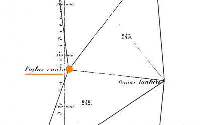
Location Luvddiidčohkka / Lodiken. Kautokeino, Troms og Finnmark, Norway. Coordinates Lat. 69° 39' 52" NLon. 23° 36' 8"EHeight 639 m Status Unesco World Heritage List, Site No. 3 Measurement point of the Struve Geodetic Arc No. 10 Main station pointMap of the area...
Lille-Raipas, Norway
Location Lille-Raipas. Alta, Troms og Finnmark, Norway. Coordinates Lat. 69° 56' 19" N Lon. 23° 21' 37" E Height 286 m Status Unesco World Heritage List, Site No. 2 Extension network measurement point of the Struve Geodetic Arc Map of the area Sightlines to...
Fuglenes, Norway
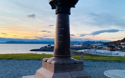
Location Fuglenes. Hammerfest, Troms og Finnmark, Norway Coordinates Lat. 70° 40' 12" NLon. 23° 39' 48" EHeight 14 m Status Unesco World Heritage List, Site No. 1Measurement point of the Struve Geodetic Arc, No. 1 Main station pointAstronomical station pointMap of the...