


F.G. W. Struve used in his calculations the measurements made in 265 main and 65 subsidiary station points. The measurement points described on this site run from Fuglenes, Norway to Ulkokrunni, Finland. The Northern parts of the Struve Geodetic Arc include 40 main station points out of 265 included in the Unesco World Heritage nomination list. All of the main station points are not World Heritage Sites. Despite that, they have an interesting history and can be surrounded by beautiful nature.
Main station points in the Northern parts of the Struve Geodetic Arc
- Fuglenes
- Håja
- Tyven
- Seilandstuva
- Gosviktind
- Koven
- Vardfjellet
- Halde
- Nuhpealáš
- Luvddiidčohkka / Lodiken
- Ávjovárri
- Caravárri
- Spielgavárri
- Muvravárri /Bealjášvárri
- Ádjit
- Stuorrahanoaivi
- Jerstivaara
- Tynnyrilaki
- Outakka
- Pessinki
- Olostunturi
- Lumivaara
- Kiuaskero
- Jupukka
- Ylinenvaara
- Olosvaara
- Paljukkavaara
- Kittisvaara
- Niemivaara
- Pullinki
- Aavasaksa
- Horrilonkero
- Huitaperi
- Perävaara
- Kaakamavaara/Tynnyrilaki
- Alatornion kirkko
- Ajos
- Alapenikka
- Rontti
- Ulkokrunni

Alatornio church, Finland
Location Alatornio, Tornio, Lappi, Finland Coordinates Lat. 65° 49' 48" NLon. 24° 09' 26" E Address: Kirkonmäentie 85 , 95450 Tornio.Height of tower 40 metres above sea level. Status Unesco World Heritage List, Site No. 11Measurement point of the Struve Geodetic Arc...
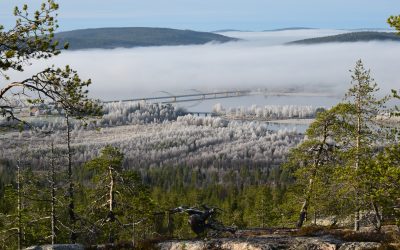
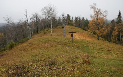
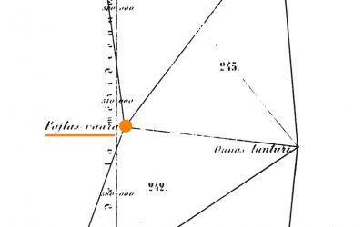
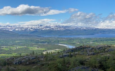
Aavasaksa, Finland
Location Aavasaksa, Ylitornio, Lappi, Finland Coordinates Lat. 66° 23' 52" NLon. 23° 43' 31" EHeight ~242 m Status Unesco World Heritage List, Site No. 10 Measurement point of the Struve Geodetic Arc No. 31 Main station pointMap of the area Sightlines to Pullinki,...
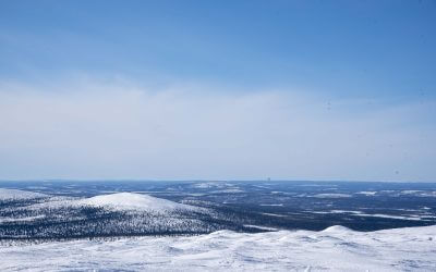
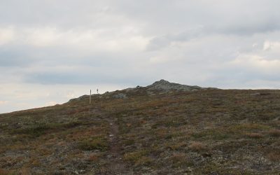
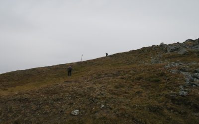
Stuorrahanoaivi, Finland
Location Stuorrahanoaivi. Enontekiö, Lappi, Finland Coordinates Lat. 68° 40' 57" N Lon. 22° 44' 45" E Height ~600 m Status Unesco World Heritage List, Site No. 9 Measurement point of the Struve Geodetic Arc No. 16 Main station point Astronomical station point Map of...
Perävaara, Sweden
Location Perävaara. Haparanda, Norrbotten, Sweden Coordinates Lat. 66º 01' 05'' NLon. 23º 55' 21'' EHeight 89 m Status Unesco World Heritage List, Site No. 8 Measurement point of the Struve Geodetic Arc No. 34 Main station pointMap of the area Sightlines to Huitaperi,...
Pullinki, Sweden
Location Pullinki. Övertorneå, Norrbotten, Sweden Coordinates Lat. 66° 38' 47'' NLon. 23° 46' 55'' EHeight 335 m Status Unesco World Heritage List, Site No. 7 Measurement point of the Struve Geodetic Arc No. 30 Main station pointMap of the area Sightlines to...
Jupukka, Sweden
Location Jupukka. Pajala, Norrbotten, Sweden Coordinates Lat. 67° 16' 36'' N Lon. 23° 14' 35'' E Height 277 m Status Unesco World Heritage List, Site No. 6 Measurement point of the Struve Geodetic Arc No. 24 Main station point Map of the area Sightlines to...
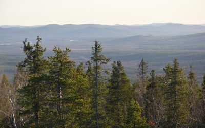
Tynnyrilaki, Sweden
Location Tynnyrilaki. Kiruna, Norrbotten, Sweden Coordinates Lat. 68° 15' 18'' N Lon. 22° 58' 59'' E Height 445 m Status Unesco World Heritage List, Site No. 5 Measurement point of the Struve Geodetic Arc No. 18 Main station pointMap of the area Sightlines to Tyven...
Muvrávarri, Norway
Location Muvrávarri / Bealjášvárri. Kautokeino, Troms og Finnmark, Norway. Coordinates Lat. 69° 1' 43" NLon. 23° 18' 19" EHeight 585 m Status Unesco World Heritage List, Site No. 4 Measurement point of the Struve Geodetic Arc No. 14 Main station point Map of the...
Luvddiidčohkka, Norway
Location Luvddiidčohkka / Lodiken. Kautokeino, Troms og Finnmark, Norway. Coordinates Lat. 69° 39' 52" NLon. 23° 36' 8"EHeight 639 m Status Unesco World Heritage List, Site No. 3 Measurement point of the Struve Geodetic Arc No. 10 Main station pointMap of the area...
Lille-Raipas, Norway
Location Lille-Raipas. Alta, Troms og Finnmark, Norway. Coordinates Lat. 69° 56' 19" N Lon. 23° 21' 37" E Height 286 m Status Unesco World Heritage List, Site No. 2 Extension network measurement point of the Struve Geodetic Arc Map of the area Sightlines to...
Fuglenes, Norway
Location Fuglenes. Hammerfest, Troms og Finnmark, Norway Coordinates Lat. 70° 40' 12" NLon. 23° 39' 48" EHeight 14 m Status Unesco World Heritage List, Site No. 1Measurement point of the Struve Geodetic Arc, No. 1 Main station pointAstronomical station pointMap of the...
Reference
Unesco Serial Nomination Table for the Struve Geodetic Arc (p. 2).Nomination of the STRUVE GEODETIC ARC for inscription on the WORLD HERITAGELIST (pdf)
https://whc.unesco.org/uploads/nominations/1187.pdf
Unesco. World Heritage List. Struve Geodetic Arc:
http://whc.unesco.org/en/list/1187/multiple=1&unique_number=1364